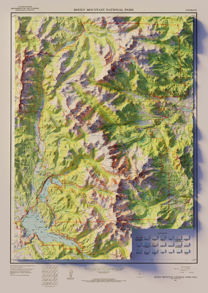
 Source
 1:00:43
Dive Deep Into the Vast Open Serengeti in 4K
Watching wild animals in their natural habitats is as exciting as nature gets. Enjoy the journey!
Aerial View of World's Largest Airplane Graveyard
Aerial photos show patterns we wouldn't notice otherwise!
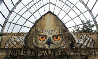
20 Works of Street Art that Send a Message to the World
This collection features some of the best street art that appeared in 2015 - perhaps you may have seen some of these works of art walking in the streets.
 8:10
8:10
Winter Hikers, Gather Round for the Best Tip of the Season
Here's how advanced snow hikers layer clothing in the winter.
 16:32
16:32
A Short Lesson in New York's Architectural History
There's no city that can compare to New York's architecture. Let's dive into it.

Food is Everywhere: Introduction to Fall Foraging
Getting bored with your garden? Go out and forage! This fall foraging guide is the perfect place to start.
 12:50
12:50
How Does He Do It? This Magician Is Beyond Incredible!
28-year-old Ben Hart magic tricks will turn even the most stern-faced skeptic into a believer. Tell us if you can figure out how he does these things, because we certainly can’t!

This Incredible Art Is Not Painted on an Ordinary Canvas
This art is not painted on an ordinary canvas. Take a look.
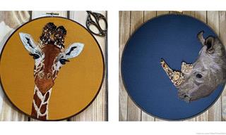
Animal Embroidery With a Beautiful Twist – 10 Pics
These beautiful animal embroidery photos have a unique twist - they are embellished with little bits of jewelry.

This Stunning Accidental Art Really is a Sight to Behold!
Here are some artworks created by Mother Nature, which are an unforeseen result of the laws of physics and gravity, and the whims of wind, light, and color.
 4:46
4:46
This Performer Will Shock and Inspire You
Once you finish watching this performance, you too will be filled with admiration for this extraordinary man who has no limbs but a lot of heart.
 7:26
7:26
You'll Need a Cold Shower After Watching This Sultry Dance...
Romance was sure in the air, during this electric dance performance. You might need a cold shower after watching this!

These 3D Embroidery Designs Look Like Real Food
Marvel at the stunning 3D food embroideries created by the artist Youmeng Liu.
 3:54
3:54
This Incredible Act Will Blow Your Mind!
We have no doubt that you will be completely dumbfounded by this act.
 4:37
4:37
This Tiny Hyper-Flexible Contortionist Will Blow Your Mind
This hyper-flexible contortionist is only ten years old, and can twist and bend her body into practically any position imaginable. View her performance here.
 3:42
3:42
This Violin Rendition of 'Unchained Melody' Is STUNNING!
Listen to one of the best renditions of the world-famous song "Unchained Melody" performed by the talented child violinist Karolina Protsenko.
 2:50
2:50
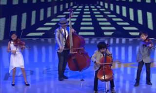
This Miniature String Quartet Know How to Spring Surprises
This string quartet called 'Joyous String Quartet' are the most talented musicians of their age I've seen so far!
 1:57
1:57
This Seductive and Seamless Salsa Routine Is Jaw-Dropping
Katee Shean and Joshua Allen are incredibly-talented salsa dancers. Watch what they can do in this truly jaw-dropping salsa routine.
 3:17
3:17
What a Spectacular Performance by 2 Classic Greats!
An exciting performance by two classic greats - Louis Armstrong and Danny Kaye!
 46:36
46:36
A Full Concert of Waltz Music and Great Classics
This beautiful concert in Vienna was held a few years ago to celebrate the new year.

Have You Read Any of the Greatest Novels of All Times?
In this article we'll discuss 12 books considered to be the greatest of all times, and see what kind of impact they made.
 4:59
4:59
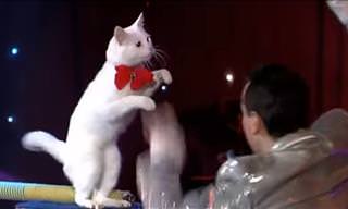
Think That Cats Can't Be Trained? Think Again!
Thought one can't train cats? Think again! This talented French trainer can get his gorgeous Angora cats to pull off amazing acts that would put most dogs to shame!
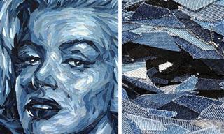
Admire Upcycled Denim Scraps Turned Into Incredible Art
Meet Deniz Sağdıç, a multimedia artist who uses upcycled denim scraps to make the most strikingly realistic portraits, some of which you might recognize!

Wow! You Won't Believe That These Are Actually Cakes!
Check out these 15 stunning illusion cakes, including cakes that look exactly like chess boards, hamburgers, and even an entire rack of glazed ribs!

MASSIVE Collection: 21 Famous Painters and Their Best Work
A beautiful collection of our most beautiful painting posts, each by a talented painter from recent centuries. This is a huge collection of classic paintings.
 6:18
6:18
These Human Voices Alone Resurrect a Totemic Rock Classic
Toto's Africa is one of my favorite songs. So I was thrilled to hear this stunning a cappella version ...

10 Perfect Movies for You to Feel That Christmas Spirit
These movies are an absolute must-watch over the holiday period. Enjoy these 10 Christmas movies today.
 2:22
2:22
You Won't Believe What This Man Did With His Tree Stump
Watch the making-of of Lueb Popoff's impressive tree sculpture, using an old tree stump and a chainsaw. What talent and precision!
 3:59
3:59
This Orchestral Masterpiece Will Bring Tears to Your Eyes
Watch Plácido Domingo's incredible version of 'Silent Night' that will bring tears to your eyes!
 6:09
6:09
Watch This Pianist Explain Musical History, Musically!
If you want to know more about the development of classical music through the centuries, this brief video is just the ticket.
 7:31
7:31
This Version of a Famous Song Brought Tears to My Eyes
If you love the song 'Hotel California,' this a capella version will blow you away. At the 4-minute mark, I was blown away!
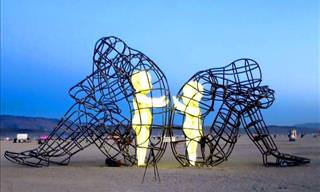
20 Modern Sculptures That Prove High Art Is Alive and Well
Here are some of the world's most notable examples of modern sculpture. These awesome designs should be in every city!

9 Famous Paintings That Have Hidden Secrets Lurking Within
Even though you have seen them before, you will have never noticed these stunning and shocking secrets lurking in these 9 masterpieces of art.

The Most Famous Masterpieces of Leonardo da Vinci
Leonardo da Vinci is widely held to be the greatest visual artist and all-round renaissance man in human history. Here are his 10 most famous art works.

This Japanese Village Holds an Annual Rice Art Festival!
Learn all about Tambo Āto, the Japanese art of rice paddy paintings

10 Life-Changing Books That You Really Must Read!
Every so often you'll come across a book that will change your life. Here are 10 such examples.
 2:27
2:27
André Rieu Plays a Terrifically Fun Funiculi Funicula!
A magnificent performance by the incredible violinist André Rieu.
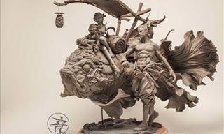
The Detail in This Artist’s Sculptures Left Me Speechless
You can't ignore the magnificent works of Yuanxing Liang, the impressive Chinese artist who manages to convey emotions with his clay sculptures ...
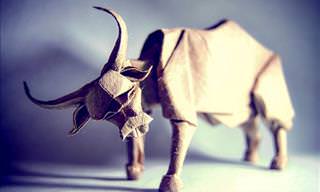
These Incredible Origami Animals Were Folded to Perfection
With only one sheet of paper, this origami expert creates the most delightful little animals
 5:24
5:24
When These 4 Sing Together, Their Music Touches Any Heart
Il Divo amaze everyone with an amazingly catchy song!

With These Piano Concertos You'll Be in Musical Paradise!
With the magnificence of the orchestra and the intimacy of a piano, these 24 classic piano concertos simply have it all!
 3:31
3:31
André Rieu Creates Another a Musical Extravaganza!
The audience got a hilarious surprise while watching André Rieu's performance, and I'm sure it will brighten your day!
 4:58
4:58
Jonglissimo Reinvents Juggling in a Mind-Blowing Way
You are invited to watch this wonderful performance yourselves and share it with all your friends who will enjoy seeing such a display of juggling, special tricks, and talent.
 3:36
3:36
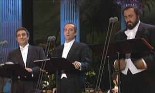
This 3-Tenor Performance is Famous For its Beauty...
Back when these 3 tenors were still with us, they made this amazing gesture to another musical genius.
 3:25
3:25
Ever Thought Music and Humor Don't Mix? Think Again!
This performance is a stunning mixture of beauty and humor. Definitely worth a watch!
 6:21
6:21
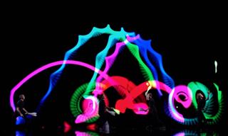
This Dance Troupe Literally Lit Up the Place!
The group The Blackouts recently reached the semi-finals of the show, soared above the stage, and left all the viewers in awe.

These Were Photographs Before Cameras Were Invented
Watch some rare, unseen watercolors of the old world before the invention of the camera.
To enable your Ad-Free Subscription, please fill the fields below
Your subscription was successful, now you can enjoy an ad-free experience!! Note: To make sure you get no ads, please make sure to log in to your account. If you are logged in already, then refresh the page. The subscription can be cancelled at any time.