New York City’s streets are subject to constant change. If it weren’t for iconic sights like the Empire State Building, the Chrysler Building, Brooklyn Bridge, and of course, the Statue of Liberty, we would hardly be able to recognize the Big Apple just a few decades ago, which is kind of fascinating... Certainly, it would be so cool to walk the streets of NYC some 80-90 years ago and see how life was like! Well, you can approximate this experience with an interactive online street map of New York City we are about to share with you.
The interactive street map is completely free to use, and it is based on digitalized archival footage of the city recorded during the 1930s and 1940s. It’s basically like a vintage version of Google Earth, and it's really fun to browse through these old photos of NYC. But how did the creators of the map find footage of virtually every building in New York?
Well, it all dates back to 1938 when the Work Projects Administration took pictures of all the taxable real estate in Manhattan, Brooklyn, the Bronx, Queens, and Staten Island on behalf of New York City’s Department of Finance. It was truly a massive endeavor, and dozens of photographers, 900 bookkeepers, and many other administrative employees were involved in taking pictures, filing, and filled out so-called “property cards” featuring photos and other information about countless buildings across the city.
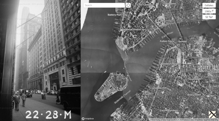
An Example of Footage You Can See Image Source: 1940s NYC
The project was halted by World War II, but thousands of photos had been filed by this time. All this footage had been digitalized in 2018 by the New York City Municipal Archives, and Julian Boilen, a software engineer, used it to create a comprehensive map, where every black dot corresponds to a photo.
The map is easy to use, and you can easily zoom in and out and move the map around with the use of the mouse. Zoom in on a street, and try clicking on a few black dots, and an archival photo will immediately appear on the left side of the screen. You can also search for specific addresses and locations by inserting the address in the search bar.
Finally, you can switch back and forth from a monochromatic photo view of the city to a regular map by clicking on the plane button at the bottom of the screen. We hope you'll enjoy the experience!
To visit the interactive map of New York City in the 1940s, click on the following link:
Please share this fun map with the New Yorkers you know!