|
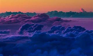
Clouds have always fascinated us. When we picture heaven, clouds usually make an appearance of some kind. They are the mysterious figures that are always hovering above us, showering us with water, and floating as if by magic. Clouds are our almost constant companions, and yet, most of us know very little about our up top neighbors. So here is your chance to learn about 10 incredible cloud formations: |
|
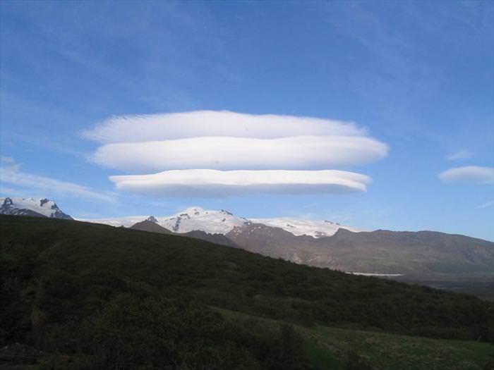
1. Lenticular Clouds
|
 |
|
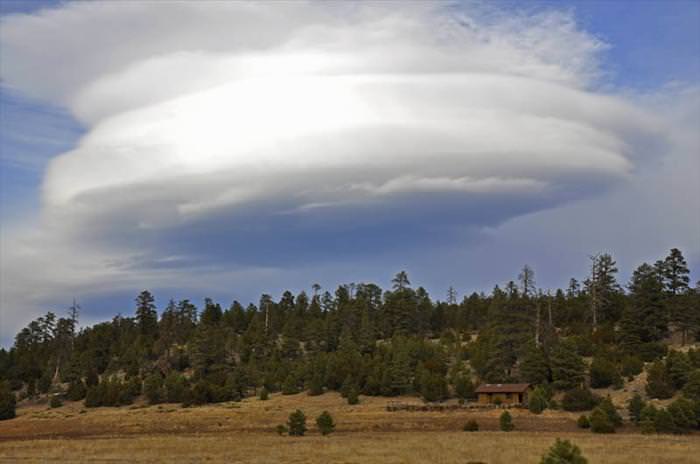
Lenticular clouds (Altocumulus lenticularis) are stationary lens-shaped clouds that form at high altitudes, normally aligned perpendicular to the wind direction. Lenticular clouds can be separated into altocumulus standing lenticularis (ACSL), stratocumulus standing lenticular (SCSL), and cirrocumulus standing lenticular (CCSL). Due to their shape, they have been offered as an explanation for some Unidentified Flying Object (UFO) sightings. |
 |
|
Where stable moist air flows over a mountain or a range of mountains, a series of large-scale standing waves may form on the downwind side. If the temperature at the crest of the wave drops to the dew point, moisture in the air may condense to form lenticular clouds. As the moist air moves back down into the trough of the wave, the cloud may evaporate back into vapor.
|
|
|
 |
|
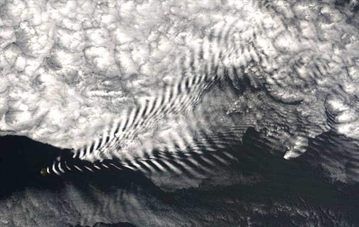
A wave cloud is a cloud form created by internal atmospheric waves. The internal atmospheric waves that form wave clouds are created as stable air flows over a raised land feature such as a mountain range and can form either directly above or in the lee of the feature. As an air mass travels through the wave, it undergoes repeated uplift and descent. If there is enough moisture in the atmosphere, clouds will form at the cooled crests of these waves. In the descending part of the wave, those clouds will evaporate due to adiabatic heating, leading to the characteristic clouded and transparent bands. The cloud base on the leeward side is higher than on the windward side because precipitation on the windward side removes water from the air. |
 |
|
It is possible that simple convection from mountain summits can also form wave clouds. This occurs as the convection forces a wave or lenticular wave cloud into the more stable air above.
|
|
3. Noctilucent (night) clouds
|
 |
|
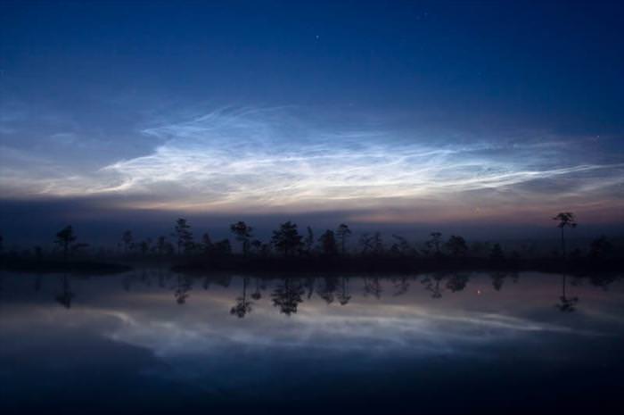
Night clouds or noctilucent clouds are tenuous cloud-like phenomena that are the “ragged-edge” of a much brighter and pervasive polar cloud layer called polar mesospheric clouds in the upper atmosphere, visible in a deep twilight. They are made of crystals of water ice. The name means roughly night shining in Latin. They are most commonly observed in the summer months at latitudes between 50° and 70° north and south of the equator.
They are the highest clouds in the Earth’s atmosphere, located in the mesosphere at altitudes of around 76 to 85 kilometers (47 to 53 mi). They are normally too faint to be seen and are visible only when illuminated by sunlight from below the horizon while the lower layers of the atmosphere are in the Earth’s shadow. Noctilucent clouds are not fully understood and are a recently discovered meteorological phenomenon; there is no record of their observation before 1885.
Noctilucent clouds can form only under very restrictive conditions; their occurrence can be used as a sensitive guide to changes in the upper atmosphere. Since they are a relatively recent classification, the occurrence of noctilucent clouds appears to be increasing in frequency, brightness, and extent. It is theorized that this increase is connected to climate change.
|
|
|
 |
|
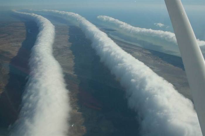
The Morning Glory cloud is a rare meteorological phenomenon occasionally observed in different locations around the world. The southern part of Northern Australia’s Gulf of Carpentaria is the only known location where it can be predicted and observed on a more or less regular basis. The settlement of Burketown attracts glider pilots intent on riding this phenomenon.
Morning Glory clouds can most often be observed in Burketown in September to mid-November when the chance to see it early in the morning is approximately 40%. A Morning Glory cloud is a roll cloud that can be up to 1,000 kilometers (620 mi) long, 1 to 2 kilometers (0.62 to 1.2 mi) high, often only 100 to 200 meters (330 to 660 ft) above the ground and can move at speeds up to 60 kilometers (37 mi) per hour. Sometimes there is only one cloud, and sometimes there are up to eight consecutive roll clouds.
The Morning Glory is often accompanied by sudden wind squalls, intense low-level wind shear, a rapid increase in the vertical displacement of air parcels, and a sharp pressure jump at the surface. In the front of the cloud, there is strong vertical motion that transports air up through the cloud and creates the rolling appearance, while the air in the middle and rear of the cloud becomes turbulent and sinks. The cloud can also be described as a solitary wave or a soliton, which is a wave that has a single crest and moves without changing speed or shape.
|
|
|
 |
|
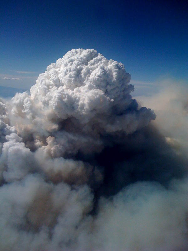
A pyrocumulus, or fire cloud, is a dense cumuliform cloud associated with fire or volcanic activity. A pyrocumulus is similar dynamically in some ways to a firestorm, and the two phenomena may occur in conjunction with each other. However, one may occur without the other. A pyrocumulus cloud is produced by the intense heating of the air from the surface.
The intense heat induces convection, which causes the air mass to rise to the point of stability, usually in the presence of moisture. Phenomena such as volcanic eruptions, forest fires, and occasionally industrial activities can induce the formation of this cloud. The detonation of a nuclear weapon in the atmosphere will also produce a pyrocumulus in the form of a mushroom cloud, which is made by the same mechanism. The presence of a low-level jet stream can enhance its formation. Condensation of ambient moisture (moisture already present in the atmosphere), as well as moisture, evaporated from burnt vegetation or volcanic outgassing occurs readily on particles of ash.
|
|
6. Wave windows |
 |
|
In meteorology, lee waves are atmospheric standing waves. Both lee waves and the rotor may be indicated by specific wave cloud formations if there is sufficient moisture in the atmosphere, and sufficient vertical displacement to cool the air to the dew point. Waves may also form in dry air without cloud markers. Wave clouds do not move downwind as clouds usually do, but remain fixed in position relative to the obstruction that forms them. |
|
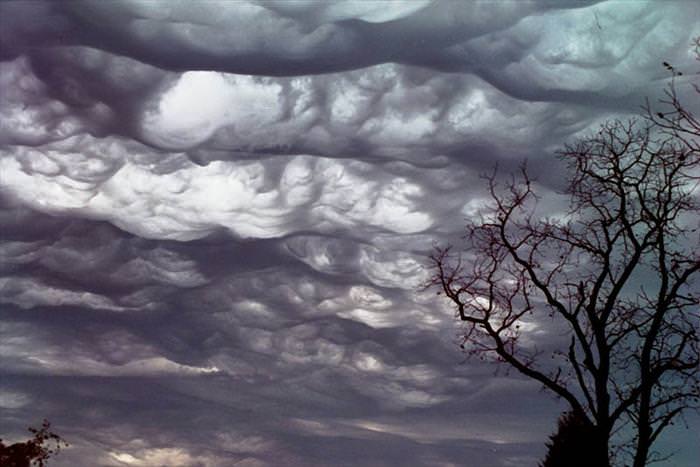
7. Undulatus asperatus |
 |
|
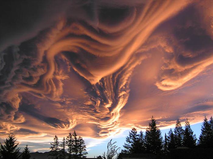
Undulatus asperatus (or alternately, asperatus) is a cloud formation, proposed in 2009 as a separate cloud classification by the founder of the Cloud Appreciation Society. If successful, it will be the first cloud formation added since cirrus intortus in 1951 to the International Cloud Atlas of the World Meteorological Organization. The name translates approximately as roughened or agitated waves. |
 |
|
The clouds are most closely related to undulatus clouds. Although they appear dark and storm-like, they tend to dissipate without a storm forming. The ominous-looking clouds have been particularly common in the Plains states of the United States, often during the morning or midday hours following convective thunderstorm activity.
|
|
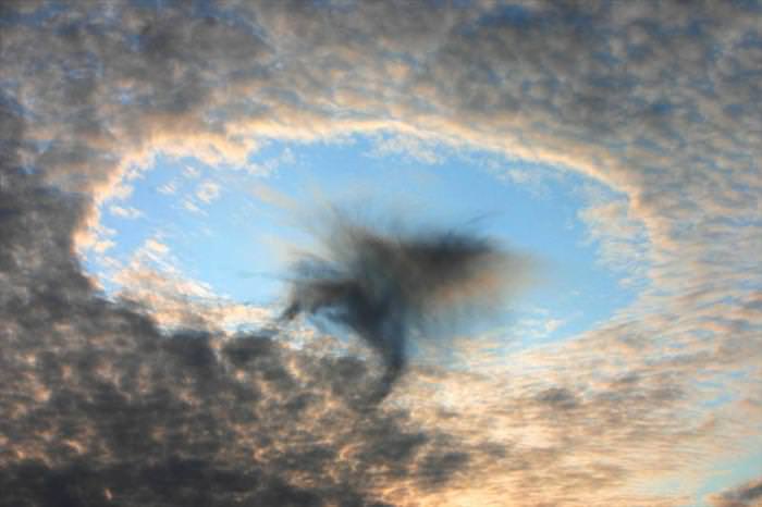
8. Fallstreak Hole or Hole Punch Cloud |
 |
|
A fallstreak hole, also known as a hole punch cloud, punch hole cloud, canal cloud, or cloud hole, is a large circular gap that can appear in cirrocumulus or altocumulus clouds. Such holes are formed when the water temperature in the clouds is below freezing, but the water has not frozen yet due to the lack of ice nucleation particles. When a portion of the water does start to freeze, it will set off a domino effect, due to the Bergeron process, causing the water vapor around it to freeze and fall to the earth as well. This leaves a large, often circular, hole in the cloud. It is believed that a disruption in the stability of the cloud layer, such as that caused by a passing jet, may induce the domino process of evaporation, which creates the hole. Such clouds are not unique to any one geographic area and have been photographed from the United States to Russia. Because of their rarity and unusual appearance, fallstreak holes are often mistaken for or attributed to unidentified flying objects. |
|
|
 |
|
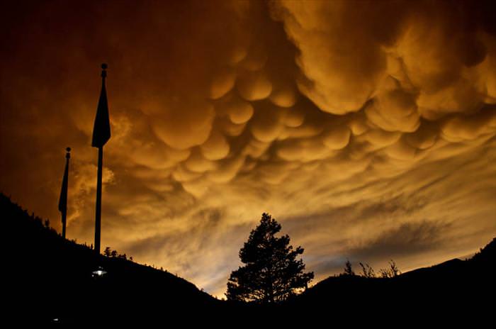
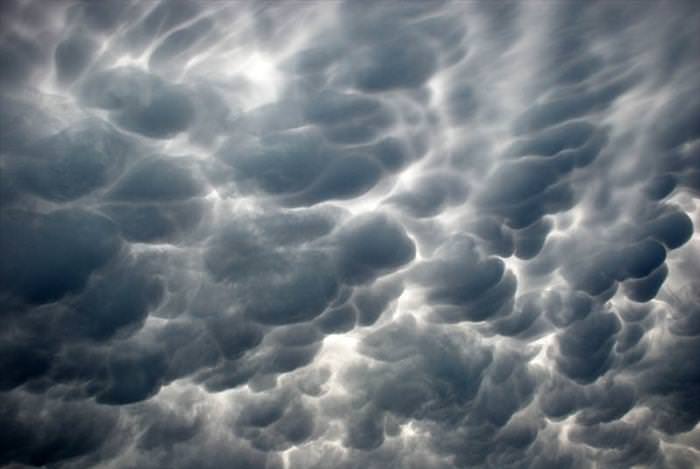
Mammatus, also known as mammatocumulus (meaning “mammary cloud” or “breast cloud”), is a meteorological term applied to a cellular pattern of pouches hanging underneath the base of a cloud. The name mammatus, derived from the Latin mamma (meaning “udder” or “breast”), refers to a resemblance between the characteristic shape of these clouds and the breast of a woman.
|
 |
|
Mammatus are most often associated with the anvil cloud and also severe thunderstorms. They often extend from the base of a cumulonimbus, but may also be found under altocumulus, altostratus, stratocumulus, and cirrus clouds, as well as volcanic ash clouds. |
|
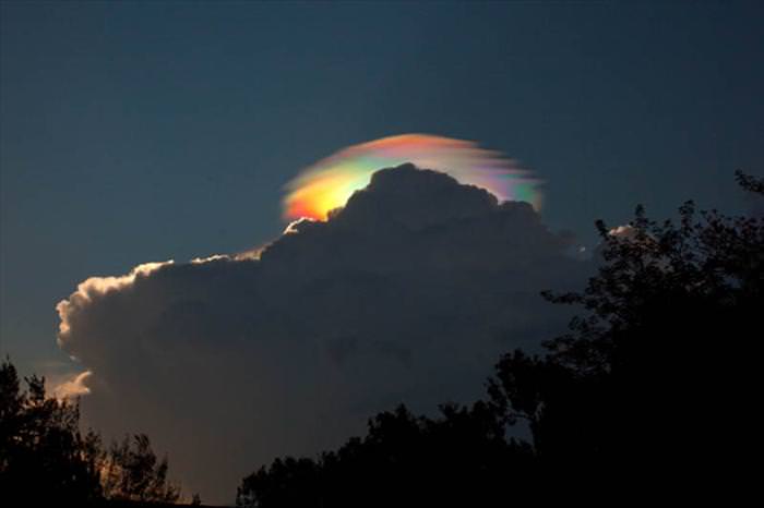
10. Cloud iridescence |
 |
|
Cloud iridescence is the occurrence of colors in a cloud similar to those seen in oil films on puddles and is similar to irisation. It is a fairly uncommon phenomenon, most often observed in altocumulus, cirrocumulus, and lenticular clouds, and very rarely in Cirrus clouds. The colors are usually pastel but can be very vivid. Iridescence is generally produced near the sun, with the sun’s glare masking it, so it can be more easily seen by hiding the sun behind a tree or building. Other aids are dark glasses or observing the sky reflected in a convex mirror or in a pool of water. Iridescent clouds are a diffraction phenomenon caused by small water droplets or small ice crystals individually scattering light. Larger ice crystals produce halos, which are a refraction phenomenon rather than iridescence. Iridescence should similarly be distinguished from the refraction in larger raindrops that makes a rainbow. If parts of clouds have small droplets or crystals of similar size, their cumulative effect is seen as colors. The cloud must be optically thin so that most rays encounter only a single droplet. Iridescence is, therefore, mostly seen at cloud edges or in semi-transparent clouds, and newly forming clouds produce the brightest and most colorful iridescence. |